A map of our border region has won an international award
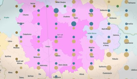
The prestigious cartographic journal *Journal of Maps* annually announces its *Best Map Awards*, which recognize the best maps of the past year. The awards do not focus solely on the best academic article or the best-designed map per se—the jury seeks an exceptional combination of both: scientific quality of content and map design. This year, a map created by two researchers from the Department of Geography at the Faculty of Science—Mgr. Martin Bartůněk and Assoc. Prof. PhDr. RNDr. Jan D. Bláha, Ph.D.—was included in this selection. Although the map did not win first place overall, its inclusion in this prestigious collection represents significant international recognition and serves as motivation for further research.
The award-winning map is part of a long-term research project by Mgr. Martin Bartůněk: identifying the boundaries of diverse regions in the border area of Bohemia, Saxony, and Lower Silesia. At first glance, a simple question—where does the Podkrušnohoří or Podřipsko region begin and end?—hides a surprisingly complex answer. This specific map examines how various institutions define these regions, and an evaluation is currently underway to determine whether these definitions align with the general public’s perception of the regions. Preliminary results reveal interesting contradictions: some regions are promoted by institutions even though people are practically unaware of them, while other regions are deeply rooted in the public consciousness but are largely overlooked by institutions.
The map can thus serve as a tool for communication between different population groups and contribute to the development of regional identities.
The research does not yield new insights solely in terms of content. An important part of the work was also finding a way to visualize the boundaries, as regions overlap in various ways within the space and the intensity of the boundary is sharper in some places than in others. Regional boundaries rarely form a sharp line, with the possible exception of national borders. The authors therefore developed approaches to express regional boundaries as a continuous transition zone—an area where one region gradually transitions into another or overlaps with it.
You can find more about the Czech contribution among this year’s Best Map Awards winners from the Journal of Maps in an article on the gisportal.cz website
#scienceUJEP #geografienaujep